IWRM Shandong, China
Problem description
 Water scarcity and water pollution are severe problems in the Northern part of China,
seriously affecting socio-economic development and standards of living and environment
. The per capita water volume
in China is one fourth of the world average. 90% of cities' groundwater and 75% of rivers are polluted.
Water scarcity and water pollution are severe problems in the Northern part of China,
seriously affecting socio-economic development and standards of living and environment
. The per capita water volume
in China is one fourth of the world average. 90% of cities' groundwater and 75% of rivers are polluted.
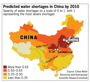
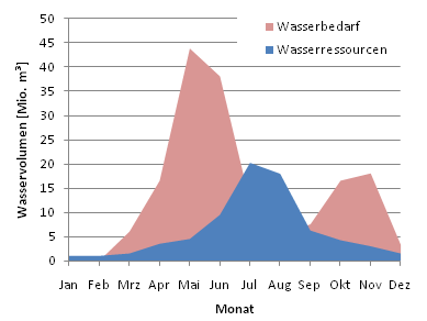
In the coastal catchments of the Shandong province the water scarcity is even increased due to salt water intrusion, reducing the usability of available water resources. In our study area, the Huagshuihe river basin, the problam is even more severe due to the monthly and annual distribution of water resources and water demand.
IWRM
 Integrated Water Resources Management (IWRM) has been defined by the
Technical Committee of the Global Water Partnership (GWP)
as "a process which promotes the coordinated development and management
of water, land and related resources, in order to maximize the resultant
economic and social welfare in an equitable manner without
compromising the sustainability of vital ecosystems."
It is clear that deciding about water management measures is a complex process in IWRM.
The management options and their implications have to be clearly and understandibly communicated to all stakeholders.
But how can we efficiently analyse management implications on this intricate network of water related processes from different
social, economical and even geographical and political levels?
Integrated Water Resources Management (IWRM) has been defined by the
Technical Committee of the Global Water Partnership (GWP)
as "a process which promotes the coordinated development and management
of water, land and related resources, in order to maximize the resultant
economic and social welfare in an equitable manner without
compromising the sustainability of vital ecosystems."
It is clear that deciding about water management measures is a complex process in IWRM.
The management options and their implications have to be clearly and understandibly communicated to all stakeholders.
But how can we efficiently analyse management implications on this intricate network of water related processes from different
social, economical and even geographical and political levels?
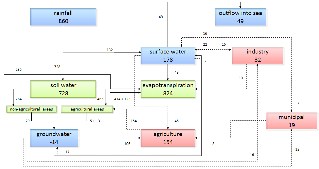
We have designed a three-level decision support system that analyses management options on a global/national, regional and local scale and, -respectively- filters, translates & dimensions and situates the possible measures.Not all measures or management options can be applied everywhere. In DSS0, the decision maker is asked to enter general information about the project area like coordinates, location, average rainfall, ... The programm then automatically filters out from the multitude of possible measures those that are not applicable to the project area. In other words, we have transformed the applicability of a wide range of measures into simple questions, readily understandable for every decision maker.
Decision report
 After application of DSS0, a more or less extensive list of possible measures and management options remains
to be compared against the background of the local hydroecological situation. Of course, the regional socio-economical sectors' dependencies
of and influences on the water cycle have to be taken into account. In DSS1, we have devised a technological model to quantify the impact of each measure and transform it
into a 'common currency', which can then be evaluated against a range of other criteria using a MCDM algorithm of choice. It is connected to a GUI which allows
on the fly changes to the hydroecological system & manual insertion of different measures. The GUI displays the possible effects in real time, thus allowing the
decision maker to explore his hydroecological environment and his management options.
After application of DSS0, a more or less extensive list of possible measures and management options remains
to be compared against the background of the local hydroecological situation. Of course, the regional socio-economical sectors' dependencies
of and influences on the water cycle have to be taken into account. In DSS1, we have devised a technological model to quantify the impact of each measure and transform it
into a 'common currency', which can then be evaluated against a range of other criteria using a MCDM algorithm of choice. It is connected to a GUI which allows
on the fly changes to the hydroecological system & manual insertion of different measures. The GUI displays the possible effects in real time, thus allowing the
decision maker to explore his hydroecological environment and his management options.
To analyse all possible measures and their extent, a deterministic-stochastic analysis is used. The deterministic compoment randomly selects measures (or combinations of measures) and the stochastic module randomly inserts an extent within a previous determined range. A monte-carlo analysis shows the behaviour of the decision space and the corresponding costs and impacts and other criteria are analysed using a pareto front.
 After selecting the optimal combination of measures and their extends in the DSS1, the third DSS level will concern
itself with the geographical aspects: a spatial decision support system
3. This is still under construction.
After selecting the optimal combination of measures and their extends in the DSS1, the third DSS level will concern
itself with the geographical aspects: a spatial decision support system
3. This is still under construction.