Erosion Hazard Assessment
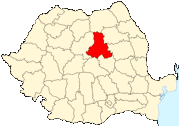
Harghita County, Romania
 In a European development project for the eastern states, technology and know-how was to be transfered.
Together with an IT-company colleague, I was sent there and in the first few weeks, whilst setting up the hardware,
we were to discuss and decide
together with the local governement on the acutal GIS-remote sensing application we were to implement.
As it turned out, in the north of Romania, in the Transylvanian mountains, deforestation had caused huge landslides
that had already cost human lives. One of the top priorities was to:
In a European development project for the eastern states, technology and know-how was to be transfered.
Together with an IT-company colleague, I was sent there and in the first few weeks, whilst setting up the hardware,
we were to discuss and decide
together with the local governement on the acutal GIS-remote sensing application we were to implement.
As it turned out, in the north of Romania, in the Transylvanian mountains, deforestation had caused huge landslides
that had already cost human lives. One of the top priorities was to:
- determine the actual risk-prone areas of future landslides
- estimate their possible impact
- find and formulate solutions
- determine 'deforestation safe-sites'
At that moment in time, large-scale maps were impossible to find in Romania, a remnant of the Chauchesku regime. Digitising and joining individual high resolution maps proved to be possible, but produced a lot of topographical and projection problems which we had to overcome.
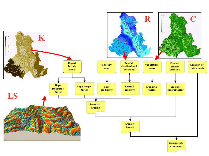 One of the central elements in our analysis was the universal soil loss equation, first formulated by Wischmeier & Smith in 1958.
So we included rainfall data, soil data, crop and vegetation coverage (from CORINE) and programmed MapInfo to calculate the topographic factors.
We verified our predicted results with the last known landslides and were able to prove to the local authority an astounding accurateness in risk
prediction.
One of the central elements in our analysis was the universal soil loss equation, first formulated by Wischmeier & Smith in 1958.
So we included rainfall data, soil data, crop and vegetation coverage (from CORINE) and programmed MapInfo to calculate the topographic factors.
We verified our predicted results with the last known landslides and were able to prove to the local authority an astounding accurateness in risk
prediction.
All in all it was a very successfull project and I still have fond memories of my time there. Researching for this website I was pleased to see that the IT-partner we worked with still uses the results of this project as one of their 'flagships': I got the picture off their website, but since it was me who actually made the maps I boldly (re)copied it for mine ;-)